

¿Como crear mi propia película?
Esta novedosa aplicación te ayuda a crear tu propia película cinematográfica con realidad aumentada si asì lo quieres. Sun Surveyor predice las posiciones del sol y la luna (azimut, altura, tiempo) con sus módulos: brújula 3D, vista de mapa, vista de cámara (Realidad Aumentada) y detalles (efemérides), permitiéndote crear tu propia película. Sun Surveyor es útil para planear fotografías y video, ubicar el posicionamiento de paneles solares, jardinería, Inmobiliaria, proyectos de Ciencias y más! Predicción y ubicación de amanecer y atardecer.
Utilice los controles interactivos para:
- Visualiza y planear la "hora dorada"
- Encontrar el momento del año y el ángulo adecuado en un lugar para hacer tomas en una ubicación determinada, al amanecer o atardecer, así como las posiciones y ruta de la luna
- Visualizar el sol y la Luna durante todo el día o todo el año, para cualquier ubicación geográfica.
- Cámara de Realidad Aumentada - Permite tener una vista de 360 grados con todos los detalles de la ubicación.
- Preparar fotografías nocturnas de la Vía Láctea y de estelas de estrellas
Características:
- Muestra el sol y Luna, longitud y altitud, marcadores del amanecer y atardecer, coeficiente de sombra, donde sale y donde se oculta la luna, fase lunar y porcentaje de iluminación, horas del Crepúsculo, (¡nuevo!) Rutas de solsticio de invierno y verano.
- Visualización de la Vía Láctea y su centro, estelas de estrellas y brújula celeste.
- Brújula 3D - una proyección 3D de las posiciones del sol y la Luna y eventos superpuestos en una brújula que representa el rodamiento del dispositivo y la orientación en el mundo
- Mapa de vista - Permite ver las posiciones singulares del Sol y la Luna superpuestas en un mapa interactivo. Permite fijar un punto en el mapa y alinearse con los puntos singulares de la posición del Sol y la Luna. Utiliza la nueva API de Google Maps que incluye mapas del terreno, así como la posibilidad de rotar e inclinar la vista del mapa. También permite calcular la altitud sobre el nivel del mar de posiciones concretas e incluso determinar la diferencia de altitudes entre dos ubicaciones.
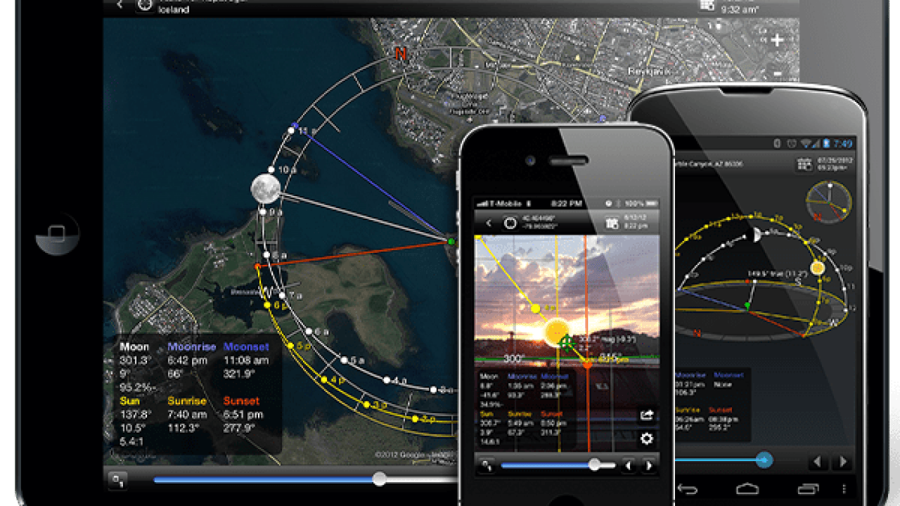
- Cámara de Realidad Aumentada - a través de la cámara del teléfono, puede visualizar dónde el sol y la Luna estará en el cielo, o cuando pasan detrás de un edificio.
- Oportunidades de foto - Una lista interactiva de momentos críticos para ayudar a inspirar y generar ideas de toma; incluyendo la luna llena que asoma baja en el cielo durante la hora mágica, la oscuridad total para observar las estrellas y más...
- Búsqueda de localizaciones - una herramienta muy poderosa para buscar el Sol, la Luna y las posiciones del centro de la Vía Láctea dentro de las diversas limitaciones establecidas ¡Para el planificador perfeccionista!
- Importación y Exportación de Ubicaciones - (¡nuevo!) importar marcas de posición de Google Earth .kmz / .kml y exportarlas para compartirlas con otros o como copia de seguridad.
Maquina del tiempo - visualizar eventos para un solo día, o ver los días más largo o más cortos y la ruta de la Luna y consiga verlos en cualquier época del año, presente o pasada.
- Uso fuera de línea (excluyendo la vista del mapa) - Introduzca coordenadas, guárdelas y vuélvalas a consultar sin conexión de datos y con el GPS apagado.
- Guardar imágenes y capturas de pantalla de la cámara de Realidad Aumentada.
- Coeficiente de sombra de sol
- Ver hacia donde se dirige la sombra del sol y predecir su proyección
- Detección automática de la zona local y uso horario.
- Compensación por declinación magnética.
- Útil para trabajos de ingeniería civil, como geolocalización y georeferenciación del norte magnético y norte geográfico.
How do I create my own movie?
Sun Surveyor predicts the positions of the sun and the moon (azimuth, altitude, time) with its modules: 3D compass, map view, camera view (Augmented Reality) and details (ephemeris), allowing you to create your own movie. Sun Surveyor is useful for planning photos and video, positioning solar panels, gardening, real estate, science projects and more! Sunrise and sunset forecast and location.
Use the interactive controls to:
- Visualize and plan the "golden hour"
- Finding the time of year and the right angle at a location to shoot at sunrise or sunset, as well as the positions and path of the moon
- Display the sun and moon all day or all year round, for any geographic location.
- Augmented Reality Camera - Allows you to have a 360 degree view with all the details of the location.
- Prepare nighttime photos of the Milky Way and star trails
Characteristics:
- Shows the sun and moon, longitude and altitude, sunrise and sunset markers, shadow coefficient, where the moon rises and where it sets, moon phase and percentage of illumination, twilight hours, (new!) Winter and summer solstice routes.
- Visualization of the Milky Way and its center, star trails and celestial compass.
- 3D compass - a 3D projection of the positions of the sun and the moon and events superimposed on a compass that represents the bearing of the device and orientation in the world
- View map - Allows you to see the unique positions of the Sun and Moon overlaid on an interactive map. Allows you to set a point on the map and align with the unique points of the Sun and Moon position. It uses the new Google Maps API which includes terrain maps as well as the ability to rotate and tilt the map view. It also allows you to calculate the altitude above sea level of specific positions and even determine the difference in altitude between two locations.
Giveaway: Win a Free Copy of the Sun Surveyor App for Your iPhone ...
- Augmented Reality Camera - through the camera on your phone, you can visualize where the sun and moon will be in the sky, or when they pass behind a building.
- Photo Opportunities - An interactive list of critical moments to help inspire and generate shooting ideas; including the full moon rising low in the sky during magic hour, total darkness to observe the stars and more ...
- Location Searching - a powerful tool for finding the Sun, Moon, and positions of the center of the Milky Way within the various constraints set by the perfectionist planner!
- Importing and Exporting Locations - (new!) import Google Earth placemarks .kmz / .kml and export them to share with others or as a backup.
Time Machine - view events for a single day, or view longer or shorter days and the path of the moon and get them viewed at any time of the year, present or past.
- Offline use (excluding map view) - Enter coordinates, save and recall them without data connection and with the GPS turned off.
- Save images and screenshots from the Augmented Reality camera
- Sun Shading Coefficient
- Seeing where the sun's shadow is going and predicting its projection
- Automatic detection of the local area and time use
- Compensation for magnetic declination.
- Useful for civil engineering works, such as geolocation and georeferencing of magnetic north and geographic north.


